Last edited: March 7, 2024
Published: May 6, 2022

Daniel O'Donohue
MapScaping Podcast Host
Blog Post
Last edited: March 7, 2024
Published: May 6, 2022
Daniel O'Donohue
MapScaping Podcast Host
EO-TIP: AIS and S-AIS are the predominantly used technologies for tracking ships on the open ocean from space. Read this article to know more.
In the past decade, between 2011 and 2020, around 876 vessels went missing at sea. Statista cites that the majority of the ships lost around this timeframe were cargo ships — totaling 348 vessels. While these vessels had no saving hand in their distress, the fishing vessel, Hallgrimur, had a miraculous escape — thanks to satellite-based AIS technology.
On January 25, 2012, Hallgrimur was caught in terrific weather conditions and overturned on the icy water between Iceland and Norway. When the rescue coordination center started receiving distress signals, the vessel was battling winds at 60 - 70 knots per hour and a wave height of 50 - 60 feet. In an effort to enhance the rescue operations, Norway’s Joint Rescue Coordination Center began tracking the ship’s AIS signal from the International Space Station.
In this course, they picked up the AIS signal of another vessel somewhere close to Hallgrimur, which they engaged in a search for the four-member crew of the fishing vessel, aided by helicopters. While the others didn’t make it, the rescue party was able to save Eiríkur Ingi Jóhannsson, who spent four hours floating on the North Atlantic Sea before aid arrived.
Had it not been for the satellite-based AIS, Hallgrimur would have been another ship in distress, lost to the perils of the sea. Incidents such as these broadcast the importance of marine trackers without which tracking ships and monitoring their course would be impossible. Thankfully, technology has stepped in and we have advanced from terrestrial ship locators to space-borne international ship finders.
In this article, we’ll enlighten you on the need for tracking ships, along with the technology that’s used to find vessels.
There are primarily four reasons why marine trackers are onboarded with vessels. Let’s look at them briefly.
Vessel tracking: Tracking ships is vital to ensure safer ship routing, enable Vessel Traffic Monitoring and Information Systems (VTMIS), promote ship reporting, establish remote region monitoring, validate ship declarations, offer efficient Vessel Traffic Services (VTS), manage arrivals, and perform effective vessel traffic analysis.
Search and rescue: During testing times, marine trackers are used for tracking and assisting distressed vessels, in casualty altering, and in bringing natural disaster relief.
Security and surveillance: Ship locators also play a crucial role in maintaining security in the oceans by monitoring piracy, preventing smuggling, mitigating infectious disease, increasing vessel safety in hostile waters, identifying vessels with radar and digital imagery, and monitoring aids to navigation operations.
Environment: Lastly, ship locators ensure that vessels do not pollute the waters. They aid in environmental preservation and fisheries protection.
A Vessel Tracking System is used to find ships in the open waters. Naturally, there are various VTS available in the market, but the predominantly used three are:
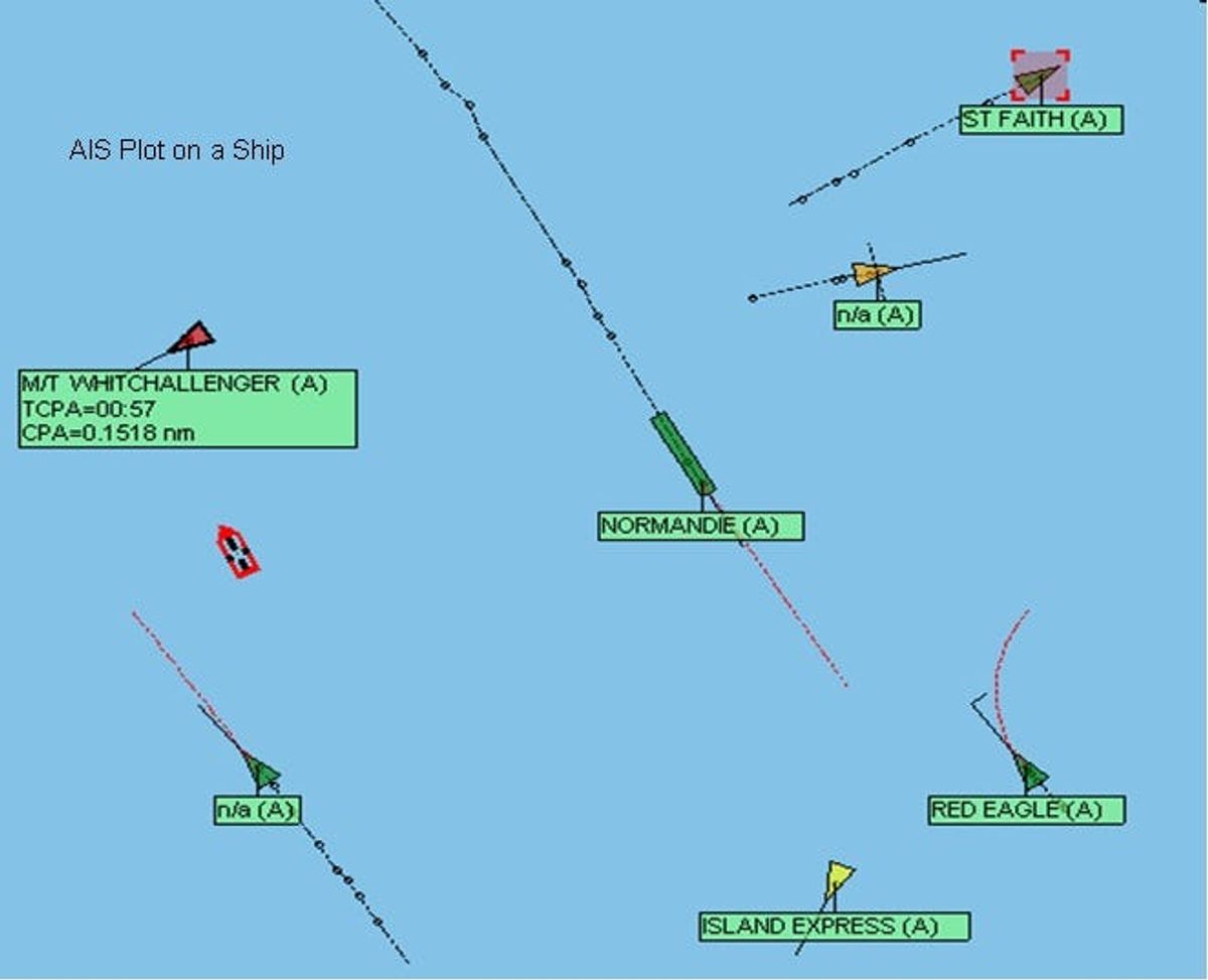
AIS stands for Automatic Identification System. It is a standardized transponder that is mounted on vessels as per the regulations posed by the International Maritime Organization. The AIS provides the position, identification, and other information pertaining to a ship to other ships and coastal authorities automatically. It is similar to air traffic control for the sea.
The Global Positioning System (GPS) works by picking up signals from the satellite. As a VTS, the GPS clearly pinpoints the position and the location of the vessel in the open waters. This comes in handy should an untoward incident crop up.
By using GPS, the vessel would be informed of what routes to take, what courses to avoid, and be kept in the loop of other important navigation guidelines.
Ship Loc is a private VTS solution that can be onboarded in vessels to give authentic readings pertaining to the location and position of a vessel, the air pressure in the oceanic area it is coursing through, the wave pressure, and all other natural and man-made occurrences that are vital to the ship’s navigation.
Besides the aforementioned three Vessel Tracking Systems, there are several others in the market. Nonetheless, AIS as a Vessel Tracking System has gained significant prominence and has been under research and development over these years that it has been upgraded to S-AIS, satellite-based AIS.
The International Marine Organization has laid forth particular standards regarding the carriage of AIS. All vessel owners must ensure that ships of 300 gross tons and above going on international voyages, cargo ships of 500 gross tons and above going on domestic voyages, and all passenger ships irrespective of their sizes are to be onboarded with the AIS.
These vessels that are fitted with the AIS must keep it functioning at all times. An exception to this standard can be observed where international agreements, standards, rules provide for the protection of navigational information. Nonetheless, while the AIS is in operation it must:
The AIS operates terrestrially. The system consists of one Very High Frequency (VHF) transmitter, two VHM Time-Division Multiple Access (TDMA) receivers, one VHF Digital Selective Calling (DSC), and a standard marine electronic communication link to sensor systems and the shipboard display.
The vessels’ position and timing information is taken from an external or integral GPS receiver. All the other information broadcast by the AIS is electronically derived from the shipboard equipment via the standard marine data connections.
Theoretically speaking, only one channel is needed for the transmitting and receiving of information. Nonetheless, each station relays and receives information over two radio channels to prevent interference and avoid signal loss from vessels. Into one of the 2250 time slots established every 60 seconds, a position report from one AIS station is recorded. This way, the various AIS stations continuously synchronize themselves to each other so as to avoid slot transmission overlaps.
Although the terrestrial AIS has been playing a significant role in tracking ships, it has certain limitations that call for an upgrade in the technology.
As with other VHF digital applications, the AIS system coverage range depends on the height of the antennal. Therefore, the typical range within which vessels could be tracked is 20 nautical miles (NM). And ships that go out beyond 75 km outside the coast become invisible to the coastal authorities.
However, when the signals’ straight propagation is considered, they travel 700 km out into space. And at 408 km above the Earth is situated the International Space Station. Putting two and two together, brought about a revolution in this realm.
The European Space Agency contacted the Norwegian Defense Research Establishment and allowed their scientists to mount an AIS receiver onboard the space station.
On June 1, 2010, the system was turned on and that opened the way for the mariners to look at the global marine traffic. Indeed, this was the technology that saved Jóhannsson, the sole living crew member of Hallgrimur.
On a typical day, the space station observes around 30 thousand ships in the open ocean. This means of an international ship finder has ever since helped find ships, engage in search and rescue operations, and cater towards the greater good of the community.
While the satellite-based AIS is constantly evolving, at present there are two techniques that are used to detect the AIS signals from space.
Source: Marinegyaan.com
The OBP leverages sensitive receivers that are similar to their terrestrial equivalents in the way they operate. They cannot process the signals on their own. These are best for use in areas of low-density shipping. Nonetheless, the service quality degrades when over 1000 vessels come into the vicinity of the satellite — for the signal then begins to collide with each other.
The SDP makes use of receivers that detect, digitize the incoming signals, and process the raw files to enhance the quality. The flow of data here is faster and of higher accuracy.
Besides AIS, satellite imageries also emerge as potential ship locator solutions. They render greater range and can complement AIS in finding vessels.
GF-4 and other geostationary optical remote sensing satellites have wide coverage and a high temporal resolution. It makes them suitable for the continuous tracking and observation of vessels over a large range.
However, since optical sensors are affected by clouds, rain, the sun’s illumination, and other factors, it makes the process complicated. Nonetheless, recent research has put forth a three-staged methodology through which optical imageries can be used for tracking ships.
Image Enhancement: The optical image is first subjected to enhancement by the adaptive nonlinear gray stretch (ANGS) method. This helps to highlight the small and dim ship targets.
Target Delineation: Post the image enhancement, a multi-scale dual-neighbor difference contrast measure (MDDCM) is applied. This enables the detection of the candidate ship target’s position.
Vessel Tracking: Lastly, the joint probability data association (JPDA) method is employed for multi-frame data association and target tracking.
The results of the research have proved that ships can be detected and tracked better in this manner, as opposed to the traditional methodologies.
As with optical imagery, the SAR imageries are also used for ship detection and tracking. A research carried out by Xiangguang Leng et al, suggests the use of RADARSAT-1, RADARSAT-2, TerraSAR-X, RS-1, and RS-3 images to detect ship targets rapidly and robustly.
While using SAR, it is a two-fold approach: Ship candidate detection and ship discrimination.
Ship Candidate Detection: An adaptive land masking method is used, based on the ship and pixel size, to remove the land from the space-borne SAR images. The image is then downsampled to delineate between the big structures such as sea and islands from that of small structures — ships. Then a prescreening algorithm is used to concentrate only on the ocean bodies to locate ships.
Ship Discrimination: False alarms are difficult to eliminate in the ‘fast but dirty’ phase of preliminary ship candidate detection. Therefore, this second phase is employed to vouch against constant false alarm rate (CFAR) with the help of discrimination algorithms. They generally operate on a chip that contains a target ship candidate and its immediate surroundings and to remove false alarms by discrimination based on features and azimuth ambiguities.
This particular approach has opened the way for processing SAR images captured by different sensors, thereby, detecting ships. By the inclusion of the discrimination algorithms, the confidence level is increased, while determining ships under duress from others. We are also starting to see companies like Obrify disrupting this space and making it easier for people that are not geospatial specialists to take advantage of earth observation techniques to detect ships.
Ship locators play a crucial role in the marine traffic ecosystem. Right from tracking ships to get their position data, to finding distressed and law-violating vessels, Vessel Tracking Systems have proved to be a great blessing.
While there are many VTSs in the market, AIS and S-AIS are the predominantly used technologies to find ships. Where terrestrial AIS fails, space-borne AIS has evolved to ameliorate global marine traffic. Nonetheless, the distance limitations and satellite transmission difficulties pose core problems that impact the highly beneficial operation of the Vessel Tracking Systems.
Tracking ships from space is doable now, and is sure to see many scientific findings and developments to overcome the underlying challenges in the near future. Try Orbify if you want to start your first Earth Intelligence App for tracking vessels.